

Blue Star Completes Phase 1 Geophysics and Mobilises Phase 2 Drilling
Press Release
Vancouver, British Columbia–(Newsfile Corp. – June 10, 2026) – Blue Star Gold Corp. (TSXV: BAU) (OTCQB: BAUFF) (FSE: 5WP0) (“Blue Star” or the “Company”) announces that the Phase I exploration program over its critical mineral targets has been completed, and two drills have been mobilized to initiate the Phase 2 drilling program.
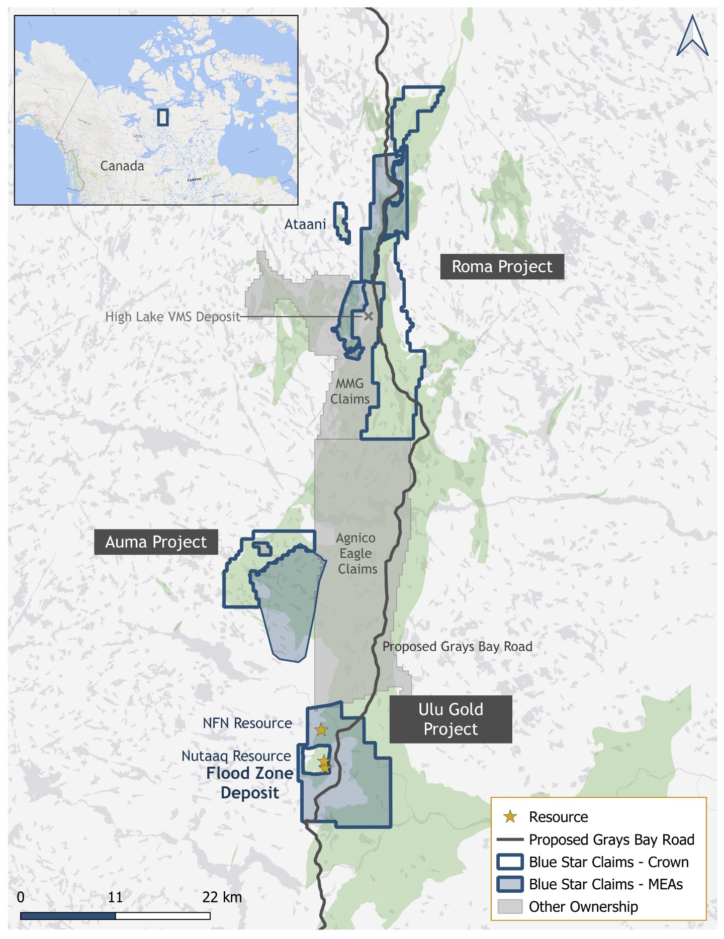
Blue Star is the dominant landholder along the proposed Grays Bay Road and Port corridor in the High Lake Belt, west Kitikmeot Region, Nunavut, Canada (Figure 1). Its properties host the high-grade Flood Zone gold deposit, and numerous gold and critical mineral targets that provide substantial upside potential for resource expansion.
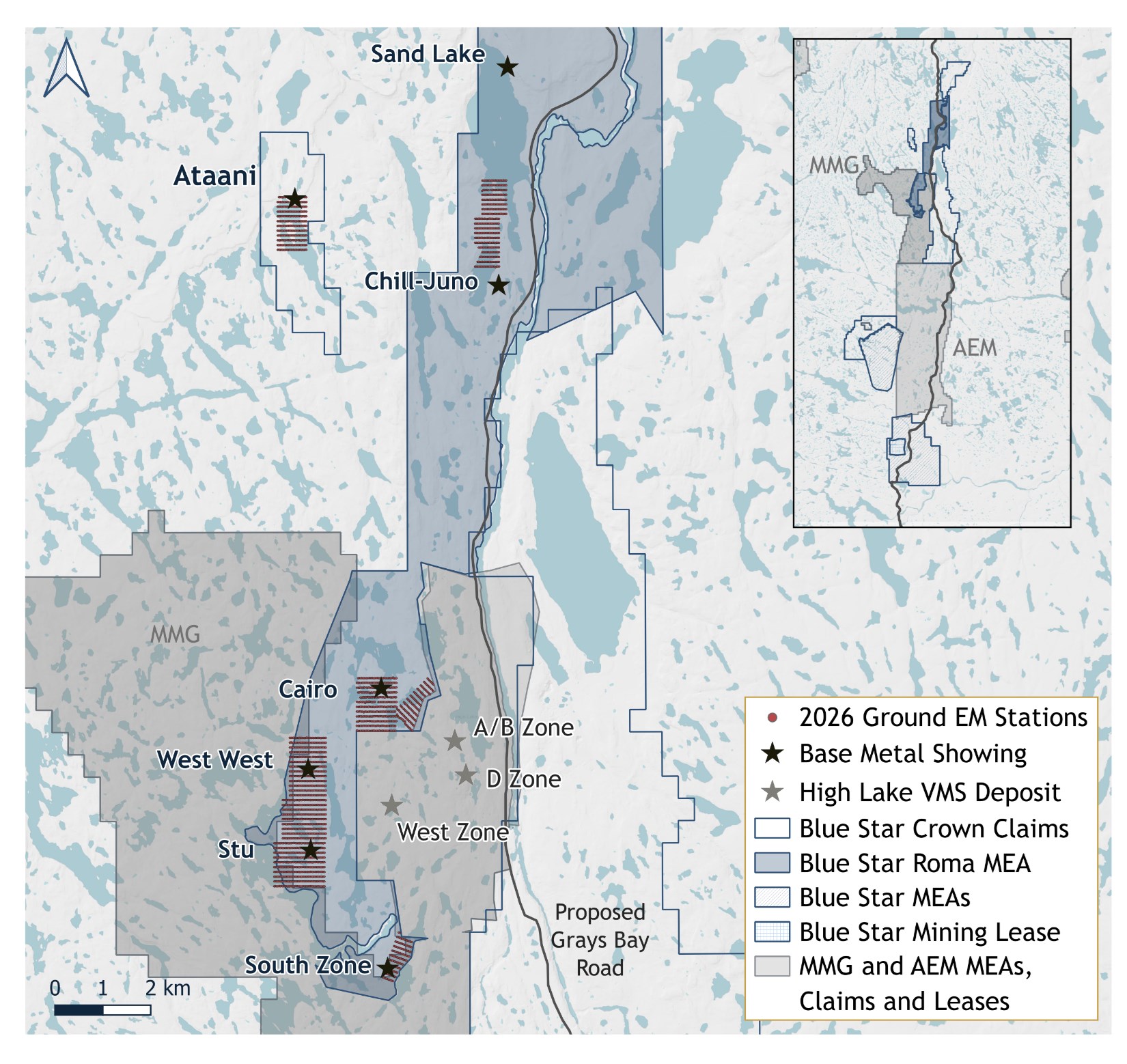
The Phase 1 program focused on advancing targets that are prospective for the discovery of critical mineral-rich volcanogenic massive sulphide (VMS) bodies, all of which are proximal to the known High Lake VMS deposit (Figure 2). The Phase 2 drilling program will commence on high-potential gold targets, followed by drill testing critical mineral targets.
Highlights
- The Phase 1 ground-based fixed loop electromagnetic (FLEM) surveys refined airborne electromagnetic plate models derived from the 2025 SkyTEM dataset
- Two FLEM crews completed 64.2 line-kilometres of surveying across nine target grids
- The high-priority target areas were defined from SkyTEM plate modelling and supplemented by compiled historical datasets
- FLEM data is being processed to refine plate targets for drill evaluation with plans to drill a minimum of five target areas
- Two diamond drill rigs have been mobilised to the site to evaluate high-potential gold and critical mineral targets
- Initial drilling will be undertaken at the Auma Project targeting high-grade gold mineralization associated with conductive alteration corridors, and North Nutaaq to follow up on 7.31 g/t gold over 5.7 metres (and proximal to 115 g/t gold in grab samples) that was drilled in 2025 (News Release dated Oct. 1, 2025)
“The successful execution of our Phase 1 program has delivered promising preliminary data, confirming high-quality drill targets,” stated CEO Grant Ewing. “Data processing for our critical mineral targets remains underway as we concurrently prepare to launch the Phase 2 drilling program, which will initially prioritize two prospective gold target areas. This sets the stage for a high-impact year, characterized by a comprehensive exploration campaign designed to maximize discovery potential and accelerate resource expansion across multiple high-priority zones.”
Critical Mineral Targets in the High Lake Belt
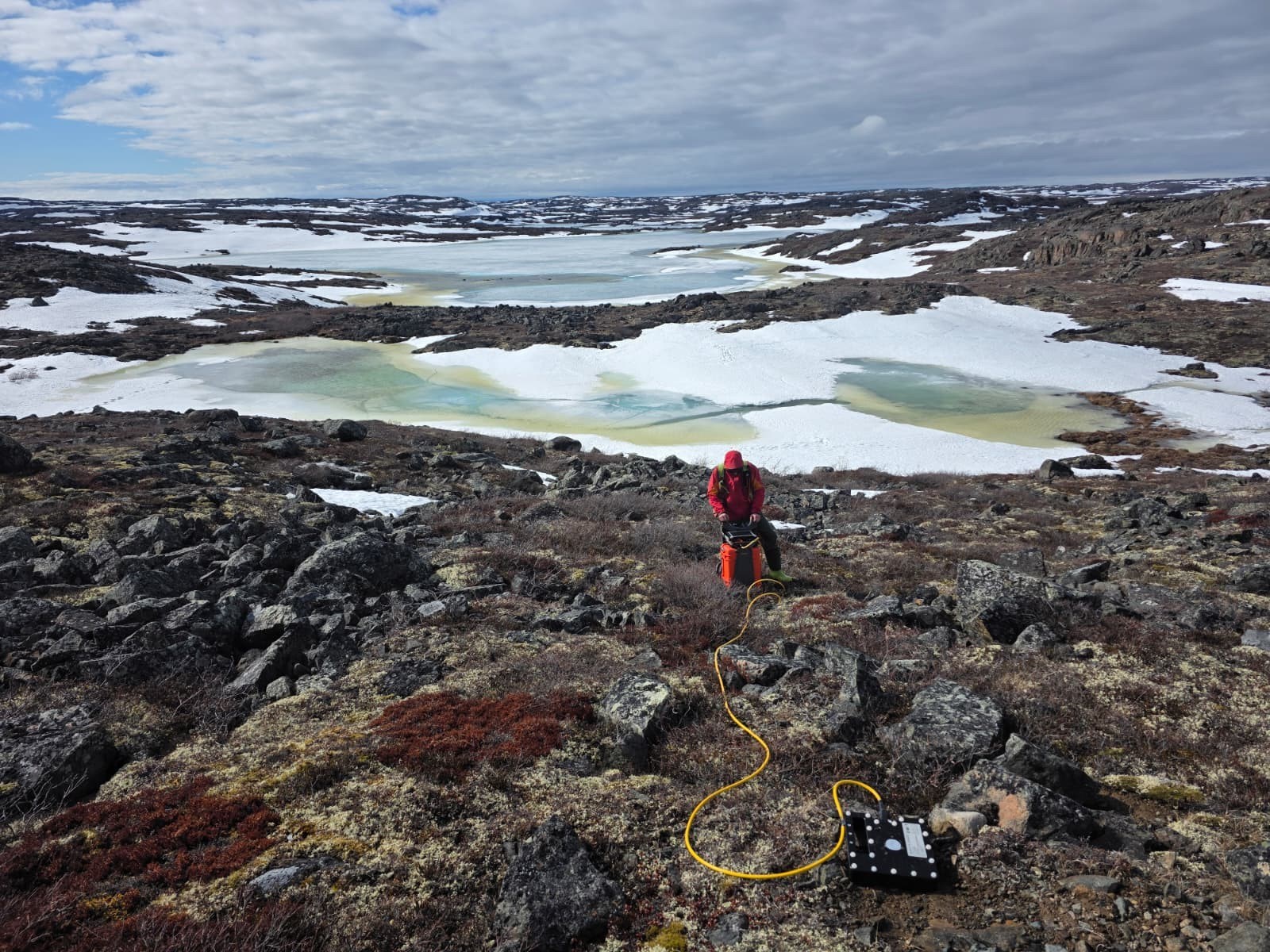
The ground loop geophysics was completed by Axiom Exploration Group Ltd, Saskatoon, SK surveying 64.2-line kilometres over nine (9) grids. including: Ataani, West West, Gap, Stu, South, Juno N., Juno S., Cairo E., and Cairo S. The grids were designed to further evaluate and refine priority conductive targets identified by the 2025 SkyTEM airborne geophysical survey (see News Release dated Nov. 13, 2025). Survey data was collected on 100 metre line spacing and 25 metre station spacing using a modern time domain electromagnetic system (Phoenix TXU30 transmitter, Emit SmartEM24 receiver and the Emit SMART Fluxgate sensor). The surveying was completed during May and June based out of the Ulu camp, and was supported by Great Slave Helicopters of Yellowknife, NT.
Conducting Ground-based FLEM Surveys on Roma Project Targets.
The Roma Project hosts numerous critical mineral prospects (Figure 2), including the Ataani massive sulphide body (17.1 metres of massive sulphide, including 2.0 metres of 10.95% zinc and 3.5 metres of 1.46% copper; News Release dated Sept. 5, 2024), and the Sand Lake exploration target (historical intersections up to 2.71% Cu over 21 metres; News Release dated April 21, 2026). Several other targets have characteristics of known VMS systems such as the presence of dalmatianite, large sodium depletion zones, chloritic alteration zones and high-grade copper values in grab samples (up to 9.99% copper from Cairo, up to 5.17% from Stu), highlighting the prospectivity for additional VMS discoveries within the Company’s landholdings.
VMS systems are characteristically developed as clusters or ‘camps’ of multiple sulphide lenses. The nearby High Lake deposit consists of three separate mineralised zones that combined represent an Indicated Resource of 7.9 Mt grading 3% Cu, 3.5% Zn, 0.32% Pb, 83 g/t Ag, and 1.3 g/t Au, and an Inferred Resource of 6 Mt grading 1.8% Cu, 4.3% Zn, 0.41% Pb, 84 g/t Ag, and 1.3 g/t Au (MMG – Mineral Resource and Ore Reserves Statement 2025), underscoring the scale of the system and the potential for additional lenses and deposits to be discovered within the broader camp. Note that the information disclosed from adjacent properties is not necessarily indicative of the mineralization on the Company’s projects.
It is anticipated that the strongest target areas from the FLEM data will undergo drill evaluation as part of the Phase 2 critical mineral drill program.
Initial Gold Targets of the Phase 2 Program
The Phase 2 drill program will evaluate high-potential gold targets as described in prior news releases. The initial gold targets include:
- The highly prospective Auma Gold Project. The main target area was upgraded by surface mapping and sampling (News Release dated Sept. 10, 2025) with some very high-grade samples from Zone 3, and numerous high-grade samples collected across the broader Auma Project area. Compilation of historical geophysics indicated a coincidence with conductivity anomalies associated with the known gold-bearing structures.
- Priority gold-focused drilling will follow up on the substantial drill intersection from North Nutaaq (7.31 g/t gold over 5.7 metres; News Release dated Oct. 1, 2025). Surface samples from a parallel structure approximately 150 metres south returned > 100 g/t gold. These targets are located 600 metres north of the Flood Zone Deposit and are a continuation of the +1,500 metre Nutaaq resource and target area. Both initially targeted structures are inferred to be ~300 meters in strike length based on coincident geophysical (Loupe), geochemical and mapping data.
- Additional 2026 Phase 1 work will include field evaluation of an approximately 800-metre strike length, structurally bound, gossanous trend along the east side of the Ulu Fold associated with abundant surface samples returning strong gold grades, inferred early and late structures, and interpreted conductive zones from geophysical data. This area has historically been defined by the South Contact – Contact – Zebra – Apex targets. The area has seen some shallow drill testing totalling approximately 2,000 metres (Davidson, 1996) with several longer drill holes reporting sulphide-rich veining in the drill logs that remain unsampled (Chernish, 2013). The Company anticipates that this area will advance to drill testing in Phase 2.
- Additional exposure of the Flood Zone Deposit at the surface below a thin glacial till cover will be conducted. This work will provide for further detailed mapping and channel sampling and is expected to improve the understanding of mineralisation and structural controls, support the potential extension of the current mineral resource to the surface and inform potential future mining approaches to the deposit.
Darren Lindsay, P. Geo. and Vice President Exploration for Blue Star, is a Qualified Person under National Instrument 43-101 (“NI 43-101”) and has reviewed and approved the technical information contained in this news release.
References
- Chernish, R. (2013): Summary Report on the 2012 Ulu Project Exploration Program, Mining Lease NL3563, Bonito Capital Corp., unpublished internal report, June 5, 2013.
- Davidson, G.I., 1996. Evaluation – Outlying Prospects, Ulu Project. Report prepared for Echo Bay Mines by Cove Exploration Services Inc., unpublished internal report.
- MMG Limited, Izok Corridor Report, November 2025. Public-Report-of-Exploration-Results-for-Izok.pdf.
Figure 1: Location Map Showing Blue Star’s Landholdings.
Figure 2: Critical Mineral Targets, Roma Project.
About Blue Star Gold Corp.
Blue Star is a mineral exploration and development company focused on Nunavut, Canada. The Company controls over 420 square kilometres of highly prospective and underexplored mineral properties in the High Lake Greenstone Belt. Its principal assets include the Ulu Gold Project – comprised of the Ulu Mining Lease and Hood River Property, and the Roma and Auma Projects. The Ulu Mining Lease hosts the high-grade Flood Zone Gold Deposit, and the Company’s broader land package contains numerous high-priority gold and critical mineral targets, providing substantial upside potential for resource expansion.
Blue Star’s projects are strategically located 40-100 km south of the proposed Grays Bay deep-water port, with the planned all-weather Grays Bay Road corridor passing very close to the Company’s Projects. The Grays Bay Road and Port Project was recently referred to the Major Projects Office. Prime Minister Mark Carney created the Office last year to fast-track infrastructure projects that are deemed to be of national importance.
Blue Star is listed on the TSX Venture Exchange (BAU), the OTCQB Venture Market (BAUFF), and the Frankfurt Exchange (5WP0). Additional information is available at www.bluestargold.ca.
For further information, please contact:
Grant Ewing, P. Geo., CEO
Telephone: +1 778-379-1433
Email: info@bluestargold.ca
Neither the TSX Venture Exchange nor its Regulation Services Provider (as that term is defined in the Policies of the TSX Venture Exchange) accepts responsibility for the adequacy or accuracy of this Release.
IBF4
![]()


