

Coast Copper Advances Modelling of its Copper Kettle Project, Northern Vancouver Island
Press Release
May 7, 2026
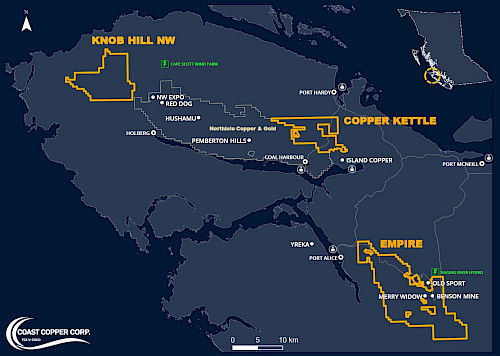
Vancouver, British Columbia – Coast Copper Corp. (“Coast Copper” or the “Company”) is pleased to announce that it has provided a comprehensive, digitized dataset for its 100%-owned Copper Kettle Project, located on Northern Vancouver Island (Figure 1) to Moose Mountain Technical Services (“MMTS”) for detailed three-dimensional geological modelling and interpretation.
Figure 1: Northern Vancouver Island
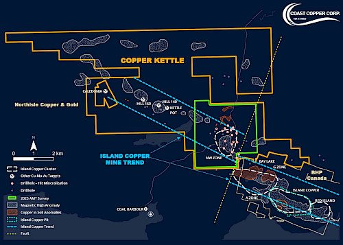
The Copper Kettle Project covers more than 5,000 hectares of mineral claims and forms part of a cluster of porphyry copper-molybdenum and gold systems (the “Island Cluster), which includes Northisle Copper and Gold Inc.’s (“Northisle”) North Island Project1 and other past-producing and advanced-stage assets. The region is increasingly recognized for its potential to host large-scale critical mineral resources, particularly copper, which is essential for electrification and energy transition initiatives. Recent support from the Government of British Columbia for the advancement of Northisle’s project underscores the strategic importance of this district and highlights a favorable policy environment for the responsible development of critical minerals (Figure 2).
Figure 2: Copper Kettle Project
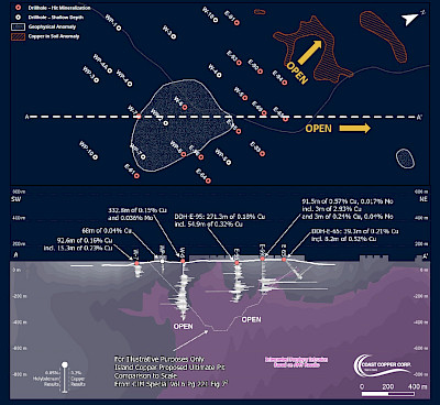
“The potential scale and continuity of mineralization at the NW Zone, which forms only about 10% of the area of the Copper Kettle Project, has exceeded our initial expectations,” said Adam Travis, CEO of Coast Copper. “Historical work points to a classic and extensive copper-molybdenum skarn system overlying a porphyry system. With modelling now underway and additional targets emerging from our geophysical programs, we believe the project is well positioned for the definition of robust drill targets in the near term.”
The Company’s review of historical exploration data has identified continuity of copper-molybdenum mineralization over an approximate 1,800 metre strike length, consistent with characteristics of a bulk-tonnage porphyry and skarn system. Historical drilling, including programs conducted by BHP between 1983 and 1989, appear to have outlined a laterally and in many cases open to depth extensive mineralized system (Figure 3).
Figure 3: Copper Kettle NW Zone Drillhole Plan and Section
The dataset provided to MMTS comprises approximately 10,000 metres of historical drilling (diamond and percussion), associated assay data, surface geological and geochemical information, and results from an AMT geophysical survey completed by Coast Copper in 2025. This work is expected to support the definition of priority drill targets and may form the basis for an Exploration Target Range, anticipated within the next one to two months.
In addition to the historically defined mineralization, recent AMT geophysical work by Coast Copper has identified potential extensions of the system at depth and along strike. A fully funded induced polarization geophysical survey is scheduled for completion as soon as permits are approved to further refine these targets.
Considering these advancements, Coast Copper has elevated Copper Kettle to flagship project status alongside its former producing Empire Mine copper-gold project which are both road accessible projects that are amenable to year-round exploration located on Northern Vancouver Island. Coast Copper’s other flagship projects are the past-producing Virginia Silver and Sweeney (Emerald) silver mines located in northcentral British Columbia near the Huckleberry Mine1 and north of the town of Smithers.
A table of Copper Kettle significant historical drill results and drill hole collar locations is available on the Company’s website (News Release Dated September 8, 2025).
The compilation and digitization of historical drilling, geological, geochemical, and geophysical datasets into a modern, quality-controlled framework provides a strong technical foundation for ongoing interpretation and future exploration.
Further updates will be provided as modelling progresses, and exploration plans are finalized.
Concurrently with this update, the Company has published an updated corporate presentation (Company presentations) outlining its strategy, flagship assets, and planned exploration activities, including anticipated milestones and timelines.
Coast Copper respectfully acknowledges that our Copper Kettle Project is located within the traditional territories of Quatsino First Nation and Kwakiutl First Nations. We are committed to collaborating with First Nations to build authentic, mutually beneficial relationships.
Qualified Persons
The technical information contained in this news release has been prepared, reviewed, and approved by Wade Barnes, P.Geo. (BC), Coast Copper’s geological consultant and a Qualified Person within the context of the Canadian Securities Administrators’ NI 43-101; Standards of Disclosure for Mineral Projects.
About Coast Copper Corp.
Coast Copper Corp. is a Canadian mineral exploration Company focused on advancing high-quality copper and precious metal projects in British Columbia. The Company’s flagship assets include the Copper Kettle copper-gold-molybdenum project, the former producing Empire Mine, and the past-producing Virginia Silver and Sweeney silver mines. In addition, Coast Copper also holds a portfolio of 16 exploration properties located within established mining districts across British Columbia, where the Company seeks to create value through a combination of prospect generation, strategic partnerships, and targeted exploration while minimizing shareholder dilution through active deal-making.
On Behalf of the Board of Directors:
“Adam Travis”
Adam Travis, Chief Executive Officer and Director
For further information, please contact:
Adam Travis, CEO
Coast Copper Corp
409 Granville Street, Suite 904
Vancouver, BC V6C 1T2, Canada
P: 877-578-9563
E: adamt@coastcoppercorp.com
IBF5
![]()


