

Discovery Reports Excellent Exploration Results from All Porcupine Targets
Press Release
February 10, 2026
Hoyle Pond1
S Zone: High-grade intersections confirm potential to extend zone to depth, to the east and west2
- 59.18 gpt over 6.2m, including 488.00 gpt over 0.70 m
- 31.33 gpt over 1.6m
- 28.73 gpt over 5.1m
- 69.34 gpt over 4.1m
TVZ: Encouraging results from infill drilling north of main target zone3
- 4.10 gpt over 30.1m, including 6.65 gpt over 4.3m, and including 7.32 gpt over 6.0m, 5.37 gpt over 1.6m and 3.9 gpt over 7.5m.
Owl Creek: New drilling 3 km west of Hoyle Pond confirms and expands mineralization between surface and 650 m level3
- 4.82 gpt over 35.7m, including 35.39 gpt over 2.1 m, and 4.51 gpt over 5.0m
- 3.45 gpt over 25.0 m, including 4.91 gpt over 14.1m
- 4.01 gpt over 6.8 m, including 27.90 gpt over 0.5m
- 2.15 gpt over 39.3 m, including 27.20 gpt over 0.8m
Borden1
Main Zone: Drilling extends mineralization to the east and northeast2
- 16.97 gpt over 14.7m, including 21.76 gpt over 10.8m
- 6.64 gpt over 12.0m
- 8.24 gpt over 15.2m, includng 17.41 gpt over 4.4m
- 20.17 gpt over 7.8m, including 104.79 gpt over 1.3m
- 11.74 gpt over 7.2m, including 18.26 gpt over 4.2m
Pamour1
Current Pit: Drilling continues to return excellent results within and along strike of current resources in all three phases of pit design3
- West Pit: 1.26 gpt over 140.0m, 0.74 gpt over 32.5m
1.13 gpt over 16.5m, 1.89 gpt over 26.7m - Central Pit: 2.53 gpt over 30.8m, 1.71 gpt over 33.6m, 2.09 gpt over 8.0m
5.20 gpt over 12.5m, 2.04 gpt over 64.5m - East Pit: 1.29 gpt over 44.8m, 1.21 gpt over 9.5m
1.50 gpt over 26.9m, 1.23 gpt over 22.2m, 2.37 gpt over 8.4m
Broulan Pit: Positive results from drilling at new Broulan target, ~1.5 km southwest of Pamour3
- 2.06 gpt over 29.6m, 4.15 gpt over 25.0m, 0.83 gpt over 8.0m
Dome1
Multiple zones of mineralization identified at Dome within and outside current resources3
- 2.50 gpt over 12.4m, and 3.97 gpt over 6.0m
- 1.47 gpt over 12.5m, including 2.55 gpt over 6.0m
- 13.64 gpt over 6.5m
- 1.61 gpt over 28.0m,
- 4.86 gpt over 18.5m, including 7.31 gpt over 12.0m
- All assays are reported uncut.
- Intervals are reported using both true widths and core lengths.
- Intervals are reported using core lengths only.
February 10, 2025, Toronto, Ontario – Discovery Silver Corp. (TSX: DSV, OTCQX: DSVSF) (“Discovery” or the “Company”) today reported results from ongoing exploration at the Company’s Porcupine Operations, including Hoyle Pond Mine, Borden Mine and Pamour Mine, as well as at the Dome and TVZ advanced stage growth projects and regional exploration targets. The results include assays from a combined total of 137 holes1 (40,823 metres (“m”)), completed between October 2025 and January 2026.
Tony Makuch, Discovery’s CEO, commented: “The exploration results announced today highlight the tremendous opportunity we have to grow resources and production in the Timmins Camp. The results include a combination of continued success with resource conversion and extension drilling at our existing operations and encouraging results from drilling at our near-term growth projects and key district targets.
“New results from Hoyle Pond include additional extensions to mineralization at depth in the S Zone and further progress establishing the zone’s potential to the east and west. At TVZ, our first hole from infill and expansion drilling on the 1210 level exploration drift intersected a wide, high-grade zone of mineralization. Work on this level is continuing, and we have also commenced drilling from the 1680 level to test the down plunge potential of the TVZ Zone. Three kilometres to the west, drill results at Owl Creek included multiple significant intercepts between surface and the 650 m level, which highlight the opportunity we have for new sources of production along the Hoyle Pond volcanic belt.
“At Borden, we continue to get encouraging results from underground drilling along a 300 m strike length of the Main Zone, with mineralization being extended both along trend to the east and northeast. We also have a surface drill targeting a high-potential trend located up to 1.2 km to the northeast of the Main Zone as we commence district drilling programs to evaluate new opportunities within Borden’s massive 1,000 km2 land position.
“Turning to Pamour, further progress was achieved confirming and extending mineralization along all three phases of the pit design. We also reported positive results from a district target near Pamour, the historic Broulan pit, located approximately 1.5 km to the southwest. We have often discussed the significant potential for Pamour to become something much larger and more valuable than currently planned, and the initial drill results from Broulan represent a first step in demonstrating that potential.
“Finally, another area of tremendous opportunity for Discovery is the prospect of resuming mining at Dome, where we currently have an 11.0 million ounce Inferred resource and considerable infrastructure already in place. Drilling commenced during the fourth quarter last year, with Initial work focused on infilling gaps in information and confirmation of historic drill holes in the southwest portion of the property where there has been limited past drilling. Results to date are encouraging and include multiple significant intercepts from both within and surrounding the current pit resource. We also recently commenced a new campaign of drilling in the northeast part of the pit and obtained additional positive results in the first hole. The current drilling is part of a 20,000 m drill program being completed in 2026 in preparation for a new mineral resource estimate targeted for late this year, with our goal being to upgrade a significant portion of the Inferred resource to the Indicated category.”
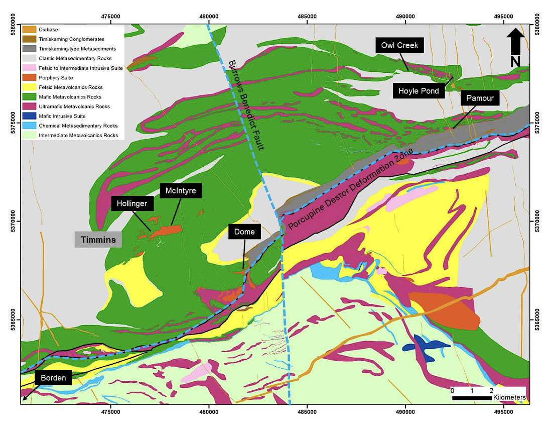
Figure 1. Location Map with Geology
Hoyle Pond Mine
Drilling at the Hoyle Pond Mine included a total of 20 holes (5,606.6m) to test the lower portion of the S Zone, the largest and highest-grade area of the mine. Of the holes drilled, eight holes (204m) were abandoned due to excessive deviation from the target.
The Hoyle Pond Mine is located approximately 20 km northeast of Timmins and is situated in the east portion of the Hoyle Pond volcanic belt adjacent to a major northeast trending flexure and the 1060 fault. Mineralization at the mine occurs in multiple zones of quartz veining between surface and a depth of 2,000m along the trend of the main flexure. The S Zone, which is the main focus of the current drill program, lies in the lower east portion of the mine, just east of the 1060 fault (Figure 2).
The twelve holes being reported were drilled mainly to test the down plunge extension of the S Zone to the east as well the lower west side where previously released holes had identified potential for high-grade lenses at depth. (Figure 3). All drilling was done from a series of platforms located on the 1860 level and on the north (hanging wall) side of the S Zone with holes intersecting the zone between the 2175 and 2275 elevations.
Key intercepts from the new drilling down plunge to the east include: 59.18 gpt over 6.2m, including 488.00 gpt over 0.7m, in hole 27685 and 31.33 gpt over 1.6m in hole 27684.
Results from the west include: 28.73 gpt over 5.1m in hole 27675Aand 69.34 gpt over 4.1m in hole 27678A.
Based on the new results, the potential to expand the S Zone and identify additional high-grade resources is considered excellent.
The program is continuing at the S Zone with three drills, which are focused on holes to depth and on the east side of the zone. Work is also ongoing to prepare several new locations in the mid-mine area for drilling which will start later in the first quarter of 2026.
Table 1: Intercepts from Hoyle Pond Underground Mine1,2,3
IBF4
![]()


