

Sun Summit Acquires 51% Ownership Share in the New Orbit Project, Toodoggone Mining District, B.C.
Press Release
Vancouver, B.C., May 14, 2026: Sun Summit Minerals Corp. (“Sun Summit“or the”Company“) (TSX-V: SMN; OTCQB: SMREF) is pleased to announce it has received confirmation from the British Columbia Ministry of Mining and Critical Minerals that 5 new mineral claims (collectively, the “Orbit Project“) totaling 6,595 hectares (66 sq. km.) have been issued in the Toodoggone Mining District, approximately 18 km equidistant north of the Flagship JD property and east of the Theory Project. The Orbit Project claims are jointly owned 51/49% with the Company’s exploration partner Eagle Plains Resources Ltd. (TSX-V: EPL; OTCQB: EGPLF) (“Eagle Plains“) and steps are underway to jointly prepare an exploration program for the 2026 season.
A formal agreement has been reached between Sun Summit and Eagle Plains whereby a definitive joint venture will be formed by December 31, 2026 to facilitate continued exploration on the property. Eagle Plains has been named the operator of the Orbit Project, and ownership will initially be split Sun Summit (51%) and Eagle Plains (49%). Planning is underway for a follow-up program in 2026 in conjunction with both the Company’s Theory and JD projects.
Highlights:
- Strategic, low-cost acquisition: Mineral rights were acquired by staking through Mineral Titles Online and issued under the new British Columbia Mineral Claims Consultation Framework. Property acquisition increases Sun Summit’s Toodoggone footprint by ~6,600 hectares, creating an attractive district-scale property portfolio of over 31,500 hectares (315 sq. km.).
- Increased land position in the Toodoggone District: The Orbit Project straddles the Quesnellia and Stikinia terranes and is underlain by prospective Early Jurassic granodioritic rocks of the Pitman Batholith in fault contact to the west with Lower to Middle Jurassic sedimentary and volcanic rocks of the Hazelton Group of the Stikine Terrane. Rocks to the north and east may represent a roof pendant of quartz-feldspathic metamorphic gneiss of unknown age and affinity but possibly Ordovician.
- Significant exploration potential: Claim staking was predicated on a jointly funded remote sensing survey completed by partners Sun Summit and EPL covering a large footprint of the Toodoggone mining district, seeking to fingerprint the alteration signature of known mineral occurrences and map the presence of alteration associated with a potential buried epithermal and porphyry systems. Within the claim boundary there are no documented Assessment Reports filed with the Government of British Columbia and no MinFile Mineral Inventory occurrences.
- Ongoing exploration planning: Once the definitive joint venture agreement between Eagle Plains and the Company is finalized and executed, the parties will decide on a jointly funded exploration program.
“The Orbit mineral claims and our agreement with Eagle Plains further strengthen Sun Summit’s foothold in the Toodoggone Mining District. Planned fieldwork in 2026 will expand our exploration presence in one of British Columbia’s most active exploration districts,” said Niel Marotta, CEO, Sun Summit.
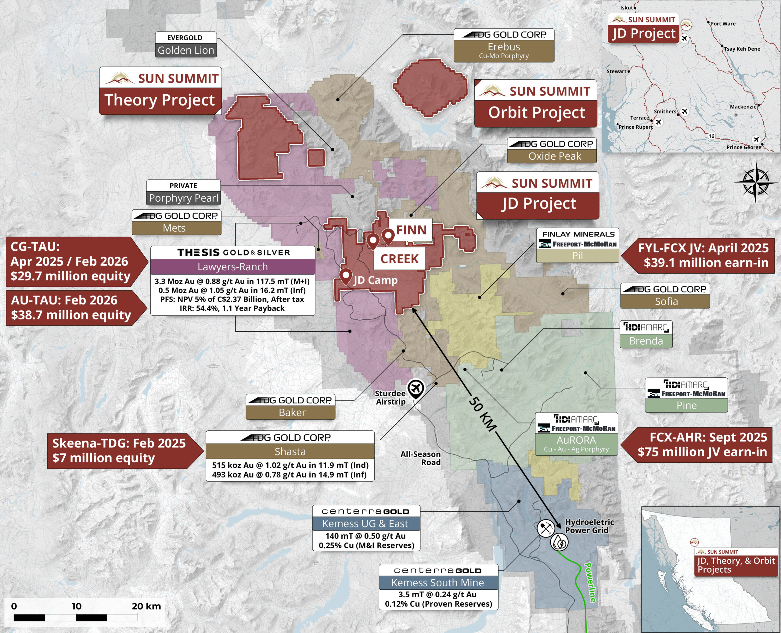
Figure 1. Map of the Toodoggone District showing the location of the JD, Theory and Orbit Projects in relation to other development and exploration projects. Data sourced from Thesis Gold & Silver Inc., TDG Gold Corp. and Centerra Gold Inc.’s respective corporate websites. The qualified person has been unable to verify the information and that the information is not necessarily indicative to the mineralization on the property that is the subject of the disclosure.
Orbit Project Recent Exploration
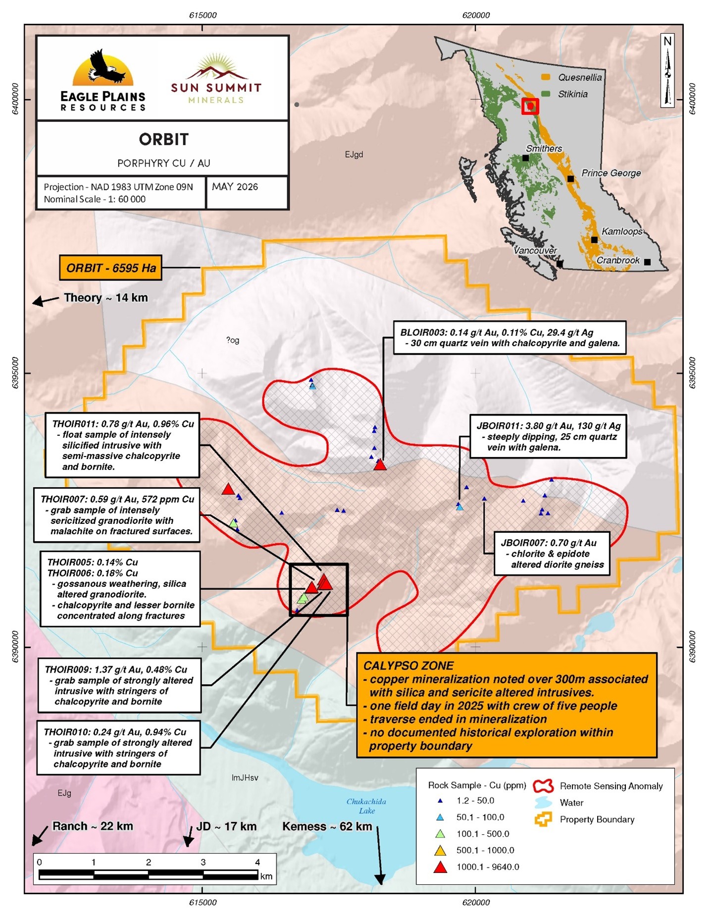
Eagle Plains and Sun Summit commissioned TerraLogic Exploration Inc. of Cranbrook, B.C. to design and execute the 2025 satellite (remote sensing) data acquisition, and follow-up field programs for the Theory and Orbit Projects. TerraLogic Exploration engaged the services of EarthDaily Analytics to interpret remote sensing datasets (SWIR-ASTER, VNIR-Sentinel, Hyperspectral-EnMap) with final products overlayed with existing compiled datasets and used to identify and prioritize targets for follow-up field study.
The core area that makes up the Orbit Project was identified through the advanced interpretation of the remote sensing data originally collected to evaluate the company’s Theory Project, located 14 km to the west and currently under option to Sun Summit. These data products provided lithological and alteration mapping to compositionally highlight alteration potentially associated with a buried mineralized system. Data was masked for water, vegetation, snow, cloud, cloud-shadow and topographic shadow to eliminate the potential for false-positives.
The Orbit Project area was identified as being highly prospective for hydrothermal alteration minerals (white mica / sericite / illite) as observed in many products (AST641, AlOB_b6, and confirmed in HIS).
Due to timing, only one field day of geological mapping, prospecting, and geochemical sampling was allocated to the Orbit Project to examine the strongest white mica remote sensing patterns. The 2025 program prospected less than 5% of the anomaly area. Several samples have been sent for petrographic analysis to Precision Petrographics Ltd. of Langley, BC, with results pending.
A total of 39 rock samples were taken on two traverses, in particular targeting quartz veins and altered intrusive compositions, including granodiorite. Highlights from the reconnaissance sampling include:
- Grab sample JBOIR011 from quartz veining in granodiorite returned 3.8 ppm Au along with 130 ppm Ag and 134.5 ppm Mo.
- Grab sample THOIR009 was a strongly altered intrusive rock with stringers of chalcopyrite and bornite which returned 1.37 ppm Au, 26.9 ppm Ag, 4,780 ppm Cu and 447 ppm Sb.
- Sample THOIR011 was a float sample from granodiorite containing abundant malachite and semi-massive chalcopyrite and bornite locally making up 40% of the rock. The sample returned 0.780 ppm Au, 10.3 ppm Ag, and 9,640 ppm Cu.
- Grab sample JBOIR007 from altered diorite gneiss, with quartz veining, returned 0.7 ppm Au and 9.5 ppm Ag.
Orbit Project Acquisition and Agreement
The Orbit Project (6,595 hectares) were issued under the new British Columbia Mineral Claims Consultation Framework which ensures British Columbia meets its duty to consult First Nations before registering claims under the Mineral Tenure Act. The application was made on September 4, 2026 and the Company was notified of successful issuance on April 20, 2026.
Orbit Project Next Steps
Planning is underway to jointly prepare an exploration program for the 2026 season to follow-up results from the brief 2025 reconnaissance style prospecting program. Details of the program will be disclosed once budgets are set and plans are finalized.
Table 1.0 Significant Assay Results – Orbit 2025 Sampling (UTM Zone 9)
| Sample | Easting | Northing | Type | Au g/t | Cu % | Ag g/t | Field Description |
| BLOIR003 | 618255 | 6393344 | grab | 0.14 | 0.113 | 29.4 | 30 cm quartz vein with chalcopyrite and galena |
| JBOIR007 | 620164 | 6392717 | grab | 0.70 | 0.005 | 9.5 | chlorite & epidote altered diorite gneiss |
| JBOIR011 | 619714 | 6392561 | grab | 3.80 | 0.009 | 130.0 | steeply dipping, 25 cm quartz vein with galena |
| THOIR007 | 617207 | 6391154 | grab | 0.59 | 0.057 | 2.6 | intensely sericitized granodiorite with malachite on fractured surfaces |
| THOIR009 | 617223 | 6391151 | grab | 1.37 | 0.478 | 26.9 | strongly altered intrusive with stringers of chalcopyrite and bornite |
| THOIR010 | 617265 | 6391164 | grab | 0.24 | 0.938 | 19.3 | strongly altered intrusive with stringers of chalcopyrite and bornite |
| THOIR011 | 617220 | 6391246 | float | 0.78 | 0.964 | 10.3 | intensely silicified intrusive with semi-massive chalcopyrite and bornite |
Figure 2.0. Select copper, gold & silver rock sample results from the Orbit Project
Quality Assurance and Quality Control
Rock samples collected during the 2025 surface program were submitted to ALS Geochemistry Ltd. (“ALS“) in North Vancouver, BC – an ISO/IEC 17025–accredited laboratory. Samples were sealed in the field, stored securely, and transported by TerraLogic personnel to maintain chain of custody.
Analytical methods for rocks included full multi-element characterization by four acid digestion with ICP finish (ALS method ME-MS61). Gold was analyzed by 30 g fire assay with AAS finish (ALS method Au AA23). Samples returning >10 g/t Au were re-assayed using fire assay with gravimetric finish (ALS method Au GRA21). Due to the small sample size and brief duration of the project there were no field duplicates or Certified Reference Material standards introduced in the field. ALS preformed internal QA/QC checks including duplicates and standards. There were no significant exceedances noted by ALS.
Qualified Person
This news release has been reviewed and approved by Sun Summit’s Vice President Exploration, Ken MacDonald, P. Geo., a “qualified person” as defined in National Instrument 43-101 – Standards of Disclosure for Mineral Projects of the Canadian Securities Administrators. Mr. MacDonald has verified the data disclosed in this press release, including the sampling, analytical and test data underlying this information that has been collected by TerraLogic. Verification procedures include industry standard quality control practices. Some technical information contained in this release is historical in nature and has been compiled from public sources believed to be accurate. Management cautions that grab sample results are not necessarily indicative of the results that may be achieved on the property.
Community Engagement
Sun Summit is engaging with First Nations on whose territory our projects are located and is discussing their interests and identifying contract and work opportunities, as well as opportunities to support community initiatives. The Company looks forward to continuing to work with local and regional First Nations with ongoing exploration.
About the JD Project
The JD Project is located in the Toodoggone mining district in north-central British Columbia, a highly prospective deposit-rich mineral trend. The project covers an area of over 15,000 hectares and is in close proximity to active exploration and development projects, such as Thesis Gold and Silver Inc.’s Lawyers and Ranch projects, TDG Gold Corp’s Baker-Shasta projects, Amarc Resource Ltd.’s AuRORA project, Centerra’s Gold Inc’s Kemess East and Underground projects, as well as the past-producing Kemess open pit copper-gold mine (Figure 1).
The project is 450 kilometres northwest of the city of Prince George, and 25 kilometres north of the Sturdee airstrip. It is proximal to existing infrastructure in place to support the past-producing Kemess mine, including roads and a hydroelectric power line.
The JD Project is in a favourable geological environment characterized by both high-grade epithermal gold and silver mineralization, as well as porphyry-related copper and gold mineralization. Some historical exploration, including drilling, geochemistry and geophysics, has been carried out on the property, however the project area is largely underexplored.
About Sun Summit
Sun Summit Minerals (TSX-V: SMN; OTCQB: SMREF) is a mineral exploration company focused on the discovery, expansion, and advancement of district-scale gold and copper assets in British Columbia. The Company’s portfolio is anchored by its flagship JD Project, alongside the Theory Project, and Orbit Project in the prolific Toodoggone region of north-central BC, and the Buck Project in central B.C. Further details are available at www.sunsummitminerals.com.
Link to Figures
On behalf of the board of directors
Niel Marotta
Chief Executive Officer & Director
info@sunsummitminerals.com
For further information, contact:
Matthew Benedetto, Simone Capital
mbenedetto@simonecapital.ca
Tel. 416-817-1226
IBF4
![]()


